Skip to content
Exploring  New Trail Routes  from Gaviota to Guadalupe

Exploring New Trail Routes from Gaviota to Guadalupe

The Northern Santa Barbara County Interim California Coastal Trail Study

  • Home
  • About the Project
  • Maps
  • Public Presentation
  • StoryMap
  • Contact

Maps

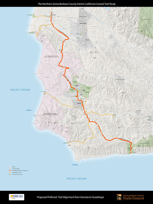
Project maps are available at the following links

Full Study Area Map with Proposed Preferred Trail Alignment

  • Study Area | Guadalupe to Gaviota (online image file)
  • Study Area | Guadalupe to Gaviota (online digital map)

Potential Off-Road Trail Connections to the Interim Coastal Trail

  • Point Sal State Park
  • Burton Mesa Ecological Reserve | La Purisima Mission State Historic Park
  • Gaviota State Park

Proposed Preferred Trail Alignment
CLICK TO VIEW LARGER MAP

Santa Barbara County Trails Council
PO Box 22352
Santa Barbara, CA 93121

logo

Santa Barbara County Association of Governments
260 North San Antonio Road, Suite B
Santa Barbara, CA 93110

logo

More About This Study

Santa Barbara County Trails Council (under contract from SBCAG) is conducting a study to determine the best trail route for hiking, cycling and equestrian riding between the City of Guadalupe and the Gaviota Coast. Please share your ideas on the best route or routes for all interests.

Get Updates


Search

Proudly powered by WordPress